
| Can we declare Winter finally over? Today's snow was mercifully non-eventful for the Easton area, and eventually mixed with and changed to rain, leaving a short-lived inch or so that melted by the afternoon. We can expect that winter-feel for another couple of days thanks to more below-average temperatures. However, we will see average temperatures (average is 55 degrees) by the end of this week. There's even better news: There's a chance for slightly above average temperatures for the beginning of next week. Want more? According to the Climate Prediction Center, April's temperatures are forecast to have an "enhanced probability to be above normal". (see map at right) There is some chatter amongst long range forecasters that by the 15th to 20th of April, we could experience well-above normal temperatures (normal is 62 degrees)! | 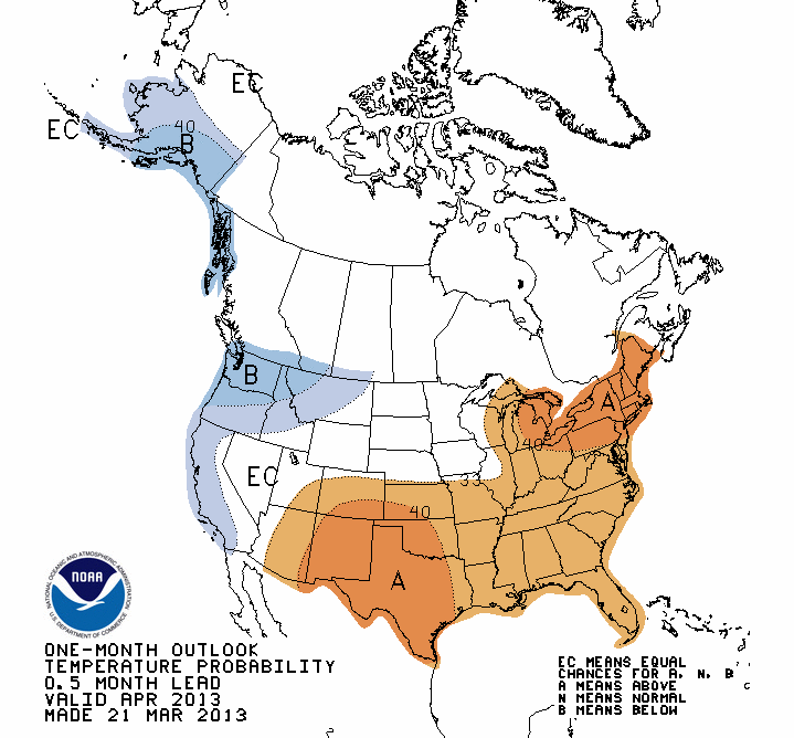 |
|
0 Comments
 No real changes from last night's post. At 6:15AM, we are still waiting for the first flakes to fall around Northampton and Warren counties. We can expect precipitation to begin some time during the morning commute.
Temperatures around the area are in the low to mid 30's this morning, which will make it hard for snow to stick on roadways. However, if snow falls hard for a period, temperatures will drop, and you may encounter slippery road conditions so be aware. The snow may mix with rain at times today. You see from the NWS map on the right, that the expected snow amounts are lowered a bit, but still a general 1-2" snowfall is possible, with a few areas perhaps receiving slightly more. The Hazardous Weather Outlook from the NWS: A SNOWFALL OF LESS THAN THREE INCHES IS EXPECTED TODAY. 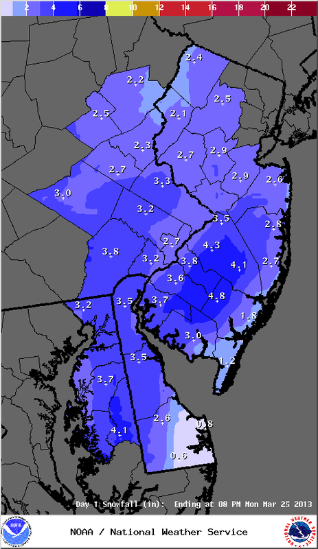 From the NWS:
THE BULK OF THE WINTRY PRECIPITATION WILL FALL ON MONDAY AND SHOULD END MONDAY NIGHT. SNOWFALL TOTALS ARE EXPECTED TO REMAIN BELOW ADVISORY CRITERIA. (NWS snowfall map on left) Impacts for Easton area: Precipitation should start around the morning commute. Temperatures will be just above freezing, making it difficult for snow to accumulate on roads. However, snow may accumulate on roads during the morning hours. The majority of precipitation will fall during the day, when temperatures will be at their warmest. There may be some rain mixing in during the afternoon. Most of the accumulation will be on grassy areas. In general, snow amounts should be around 1-2" around Northampton and Warren counties. A few isolated areas could see up to 3". As mentioned earlier, there is not a lot of confidence in the forecast, so some details could change. From the NWS:
A WINTER-TYPE STORM IN EARLY SPRING IS EXPECTED TO BRING WINTRY PRECIPITATION TO MUCH OF THE AREA BEGINNING LATE TONIGHT. THE BULK OF THE PRECIPITATION WILL FALL ON MONDAY AND SHOULD END MONDAY NIGHT. THE PRESENT FORECAST WOULD CALL FOR AN ADVISORY- LEVEL SNOWFALL, BUT CONFIDENCE IS LIMITED AND THE FORECAST IS SUBJECT TO CHANGE. A complex low pressure system is poised to hit the region late Sunday through Monday. What does it mean for Northampton and Warren counties? Precipitation could start around midnight, and it's possible we see a few tenths of an inch of snow by daybreak. What happens during the day Monday is where the forecast gets difficult. Some factors that may impact snowfall amounts? Most of the precipitation is expected to fall during the day, and marginal temperatures may make it tough for snow to accumulate on roads. Snowfall intensity will also factor in on how much we see. The lighter the snowfall, the less likely it will be able to accumulate. Elevation may play a role on accumulations as well. The higher terrain may see more snow than lower areas. Areas to the west of Easton area may see a bit more snow. Portions of Lehigh County may see up to 3" snow amounts, whereas Northampton and Warren Counties may see up to 2". This is a very fragile forecast, and many people could be surprised or disappointed, depending on their opinion of a Spring snow! From the NWS:
A WINTER-TYPE STORM IN EARLY SPRING IS EXPECTED TO BRING WINTRY PRECIPITATION TO MUCH OF THE AREA SUNDAY NIGHT THROUGH MONDAY. THE PRESENT FORECAST WOULD CALL FOR AN ADVISORY-LEVEL SNOWFALL, BUT CONFIDENCE IS LOW AND THE FORECAST IS SUBJECT TO CHANGE. An advisory snowfall would be at least 3" for the Lehigh Valley and Warren County NJ. 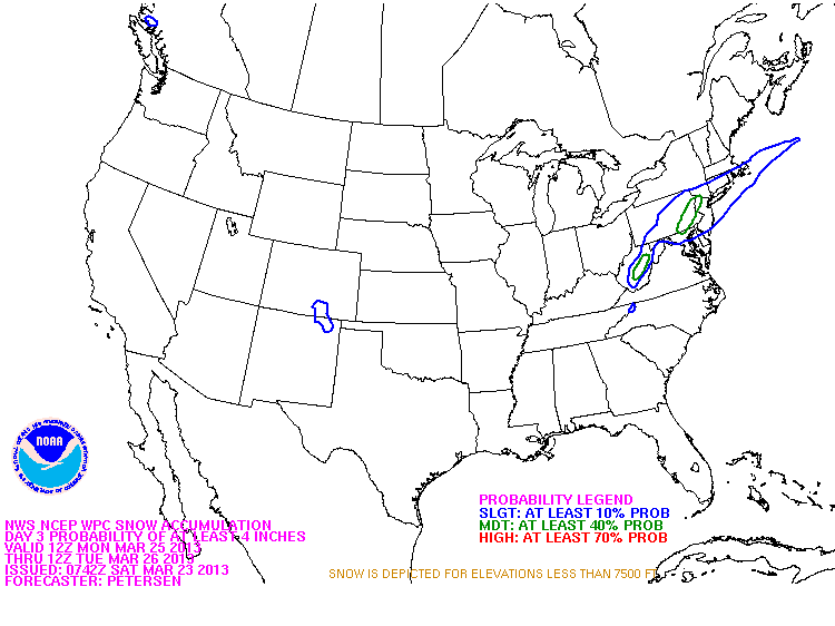 Saturday AM update from the NWS Hazardous Weather Outlook:
A WINTER-TYPE STORM IN EARLY SPRING IS EXPECTED TO BRING WINTRY PRECIPITATION TO MUCH OF THE AREA SUNDAY NIGHT THROUGH MONDAY. THE PRESENT FORECAST WOULD CALL FOR AN ADVISORY-LEVEL SNOWFALL, BUT CONFIDENCE IS LOW AND THE FORECAST IS SUBJECT TO CHANGE. Advisory level for Lehigh, Northampton, and Warren counties is 3" of snow. The map shows our area having a moderate chance of receiving a 4" snowfall (green outlined area). Again, this storm forecast has a level of uncertainty with it, so we will have to wait to see how the models handle it as it gets closer to Sunday night. 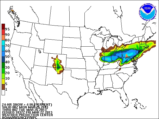 An accumulating snowfall is looking a bit more likely for the Easton area Sunday night into Monday. Nothing is written in stone at this point, as there are still some uncertainties with regards to the exact storm track, amount of liquid within this system, and precipitation types.
From the NWS: AT THIS TIME...SNOW AMOUNTS ARE EXPECTED TO BE IN THE 2 TO 4 INCH RANGE WELL N AND W OF PHILLY...1-2 INCHES LOWER DELAWARE VALLEY...TO LITTLE OR NO ACCUM NEAR THE SHORE AND SOUTHERN DE. IT SHOULD BE NOTED THAT SOME GUIDANCE LIKE THE LATEST 12Z EUROPEAN MEDIUM RANGE FORECASTING MODEL IS INDICATING CONSIDERABLY MORE SNOW. The map you see shows the probability of a 4 inch or greater snowfall between 8PM Sunday and 8PM Monday. It is tough to see, but Northampton (PA) and Warren (NJ) counties have a 50-60% chance of receiving that amount of snow according to this forecast map. This potential event is still a few days away, so there is still some changes that can occur. Stay tuned for another update Saturday. Not much has changed from yesterday's blog on the possible storm early next week for the Easton area, but there is a small bit of information that can be added.
Per the HWO (Hazardous Weather Outlook) from the NWS, it looks like the timing of the storm is focused more on Sunday night into Monday: THERE IS THE POTENTIAL FOR WINTRY WEATHER ASSOCIATED WITH A COASTAL LOW PRESSURE STARTING SUNDAY NIGHT. It is still too far out to hone in on an exact track at this time. If the storm does track up the New Jersey coast as is possible, how certain is it that we see snow instead of rain? It is late March, and the average temperature for the Lehigh Valley this weekend is 53 degrees. Normally this would signal rain. But we have had below average temperatures lately, and that trend will likely continue through the beginning of April. This will give us an opportunity for snow, or a mix, if the storm tracks up the Jersey coast. Stay tuned for more details on this storm possibility over the weekend. Even though today is the first day of Spring, we are still talking about Winter weather here in the Easton area.
Beginning late Sunday into Monday, a low pressure system will develop off the Virginia - North Carolina coast, and depending on its track, could affect our area with snow or a mix of wintry precipitation. A northward track along the New Jersey coast would likely result in winter weather for our area Monday - Tuesday, but an exact track is uncertain at this point. Here's the afternoon Hazardous Weather Outlook from the NWS today: THERE IS THE POTENTIAL FOR WINTRY WEATHER ASSOCIATED WITH COASTAL LOW PRESSURE EARLY NEXT WEEK. Expect updates in the days ahead. 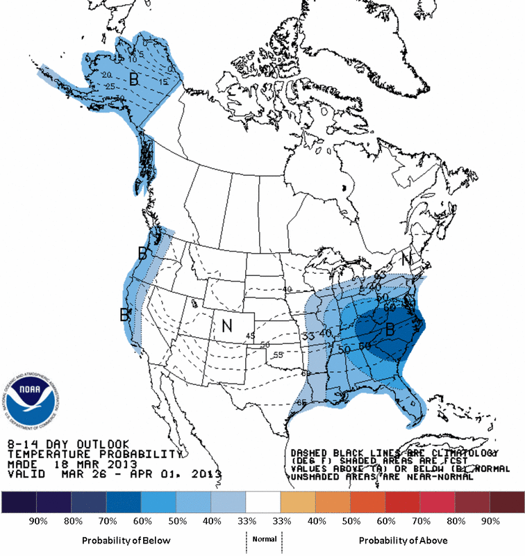 Expect below average temperatures for the Mid Atlantic region including us here in the Easton area right through the end of March, according to NOAA forecasters.
The average temperature for the Lehigh Valley for March 19 is 50 degrees, and it increases to 55 degrees by March 31. The map to the left shows the 8-14 day forecast (March 26 - April 1). Temperatures are forecast to be below average between now and March 25. Expect high temperatures to be in the low to mid 40's through this period. Not to mention, with colder than average temperatures comes chances for snow, even in March. So Spring is delayed this year. Perhaps it will arrive in April! |
Weather
|
 RSS Feed
