Here is a quick update on the Wednesday-Thursday storm potential for the Easton area:
Hazardous Weather Outlook from the NWS remains the same as late Monday (see previous post).
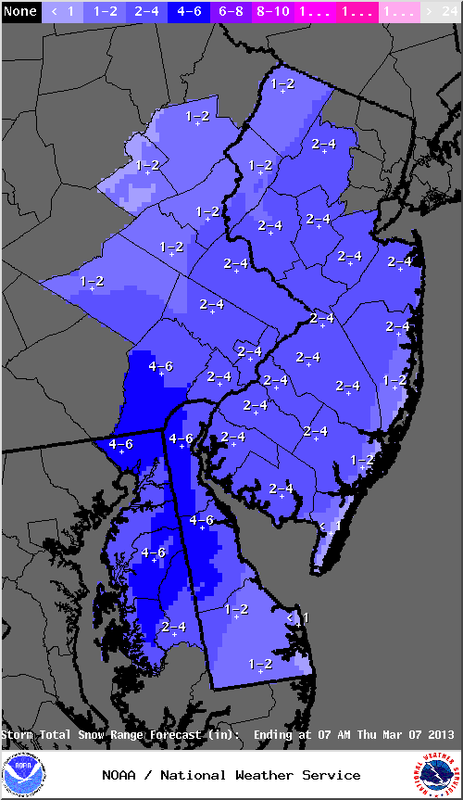
A good amount of uncertainty remains with this forecast. We could see more or less than the amounts shown on the adjacent map (courtesy of NWS).
Any accumulating snow probably won't occur until after sunset Wednesday. Expect mainly rain throughout the day on Wednesday.
This will be a wet snow. Precipitation intensity rates will determine how much snow accumulates. Light rates will mean more rain, heavier rates will mean more snow falls.
Elevation will play a role in snow amounts. Valley areas could see lesser amounts of snow than in hillier areas.
Winds will increase during the storm, causing any tree branches covered with wet snow to possibly come down, so be aware if walking or driving.
Another update by midday.
Hazardous Weather Outlook from the NWS remains the same as late Monday (see previous post).
A good amount of uncertainty remains with this forecast. We could see more or less than the amounts shown on the adjacent map (courtesy of NWS).
Any accumulating snow probably won't occur until after sunset Wednesday. Expect mainly rain throughout the day on Wednesday.
This will be a wet snow. Precipitation intensity rates will determine how much snow accumulates. Light rates will mean more rain, heavier rates will mean more snow falls.
Elevation will play a role in snow amounts. Valley areas could see lesser amounts of snow than in hillier areas.
Winds will increase during the storm, causing any tree branches covered with wet snow to possibly come down, so be aware if walking or driving.
Another update by midday.
 RSS Feed
